Volume 24, Number 2—February 2018
Synopsis
Ecologic Features of Plague Outbreak Areas, Democratic Republic of the Congo, 2004–2014
Aaron Aruna Abedi , Jean-Christophe Shako, Jean Gaudart, Bertrand Sudre, Benoit Kebela Ilunga, Stomy Karhemere Bi Shamamba, Georges Diatta, Bernard Davoust, Jean-Jacques Muyembe Tamfum, Renaud Piarroux, and Martine Piarroux
Figure 2
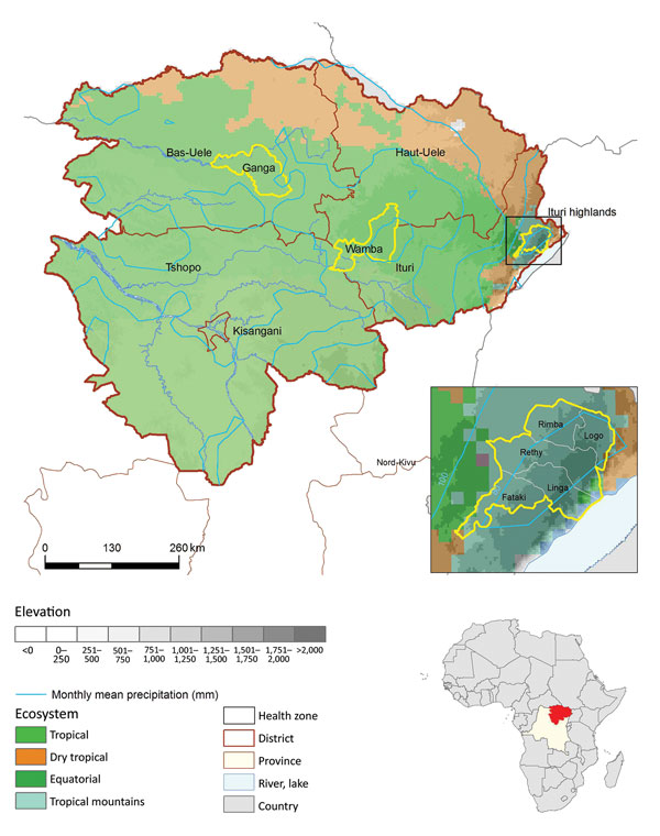
Figure 2. Location of spatial clusters of bubonic and pneumonic plague, Orientale Province, Democratic Republic of the Congo, 2004–2014. Yellow circles indicate clusters of health zones determined by spatial scan analysis. p values were <0.001, except for Wamba (p = 0.053). First inset shows the Ituri cluster constrained by frontiers; Oliveira F was 1 for Linga, Logo, Rethy, and Rimba and 0.69 for Fataki. Second inset shows location of DRC in Africa. The 4 ecosystems follow those described at http://www.fao.org/ag/AGAInfo/programmes/documents/livatl2/Ecosystems.htm (Technical Appendix Table).
Page created: January 17, 2018
Page updated: January 17, 2018
Page reviewed: January 17, 2018
The conclusions, findings, and opinions expressed by authors contributing to this journal do not necessarily reflect the official position of the U.S. Department of Health and Human Services, the Public Health Service, the Centers for Disease Control and Prevention, or the authors' affiliated institutions. Use of trade names is for identification only and does not imply endorsement by any of the groups named above.