Volume 23, Number 6—June 2017
Research
Serologic and Molecular Evidence of Vaccinia Virus Circulation among Small Mammals from Different Biomes, Brazil
Júlia B. Miranda, Iara A. Borges, Samantha P.S. Campos, Flávia N. Vieira, Tatiana M.F. de Ázara, Fernanda A. Marques, Galileu B. Costa, Ana Paula M.F. Luis, Jaqueline S. de Oliveira, Paulo César P. Ferreira, Cláudio Antônio Bonjardim, Silvio L.M. da Silva, Álvaro E. Eiras, Jônatas S. Abrahão, Erna G. Kroon, Betânia P. Drumond, Adriano P. Paglia, and Giliane de S. Trindade
Figure 2
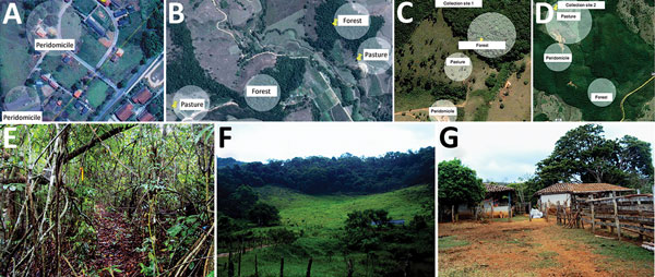
Figure 2. Location of collection sites and biomes represented in each, Minas Gerais state, Brazil. A) Collection site 1 in Serro. B) Collection site 2 in Serro. C) Peridomicile collection areas in Rio Pomba. D) Forest and pasture collection areas in Rio Pomba. E) Example of a forest area where animals were captured. F) Example of peridomicile area. G) Example of pasture area. In panels A–D, circles represent areas where transects for capture were demarcated. Sources: panels A,–D, Google Maps, modified by F.V. Nunes; panels E–G, F.V. Nunes.
Page created: May 16, 2017
Page updated: May 16, 2017
Page reviewed: May 16, 2017
The conclusions, findings, and opinions expressed by authors contributing to this journal do not necessarily reflect the official position of the U.S. Department of Health and Human Services, the Public Health Service, the Centers for Disease Control and Prevention, or the authors' affiliated institutions. Use of trade names is for identification only and does not imply endorsement by any of the groups named above.