Combined Epidemiologic and Entomologic Survey to Detect Urban Malaria Transmission, Guinea, 2018
Dean Sayre

, Alioune Camara, Yaya Barry, Touré Babacar Deen, Denka Camara, Mohamed Dioubaté, Ibrahima Camara, Kalil Keita, Nouman Diakité, Youssoufa Lo, Ibrahima Bah, Hadja Fanta Camara, Mohamed Saran Condé, Aissata Fofana, Abdoulaye Sarr, Eugène Lama, Seth Irish, and Mateusz Plucinski
Author affiliations: Centers for Disease Control and Prevention, Atlanta, Georgia, USA (D. Sayre, A. Sarr, S. Irish, M. Plucinski); National Malaria Control Program, Conakry, Guinea (A. Camara, Y. Barry, T.B. Deen, D. Camara, M. Dioubaté, I. Camara, K. Keita, N. Diakité, Y. Lo, E. Lama); Catholic Relief Services, Conakry (I. Bah); Stop Palu+, Conakry (H.F. Camara, M.S. Condé, A. Fofana); Centers for Disease Control and Prevention, Conakry (A.Sarr)
Main Article
Figure 1
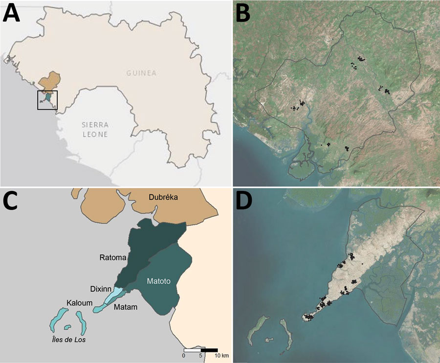
Figure 1. Administrative boundaries and location of communities visited as part of an epidemiologic–entomologic survey in Conakry and Dubréka, 2018. A) The positions of study sites are shown within the context of West Africa specifically Guinea. Turquoise area denotes Conakry and khaki Dubréka. Black square represents boundaries of the area depicted in panel B. B) Satellite imagery of Dubréka (outlined in black) and surrounding areas, with participating households shown as black points. C) Locations of 5 administrative communes within Conakry are shown in shades of turquoise; Dubréka is colored khaki. D) Satellite imagery of Conakry (outlined in black) and surrounding areas, with households participating in the survey shown as black points. Global positioning system coordinates of households were jittered for confidentiality before mapping in both (B) and (D).
Main Article
Page created: December 17, 2020
Page updated: January 24, 2021
Page reviewed: January 24, 2021
The conclusions, findings, and opinions expressed by authors contributing to this journal do not necessarily reflect the official position of the U.S. Department of Health and Human Services, the Public Health Service, the Centers for Disease Control and Prevention, or the authors' affiliated institutions. Use of trade names is for identification only and does not imply endorsement by any of the groups named above.